Department of Geodetic Engineering – Faculty of Engineering UGM

Geomatics Doctoral Program
Faculty of Engineering Universitas Gadjah Mada

Identity of Geodetic Engineering Doctoral Study Program
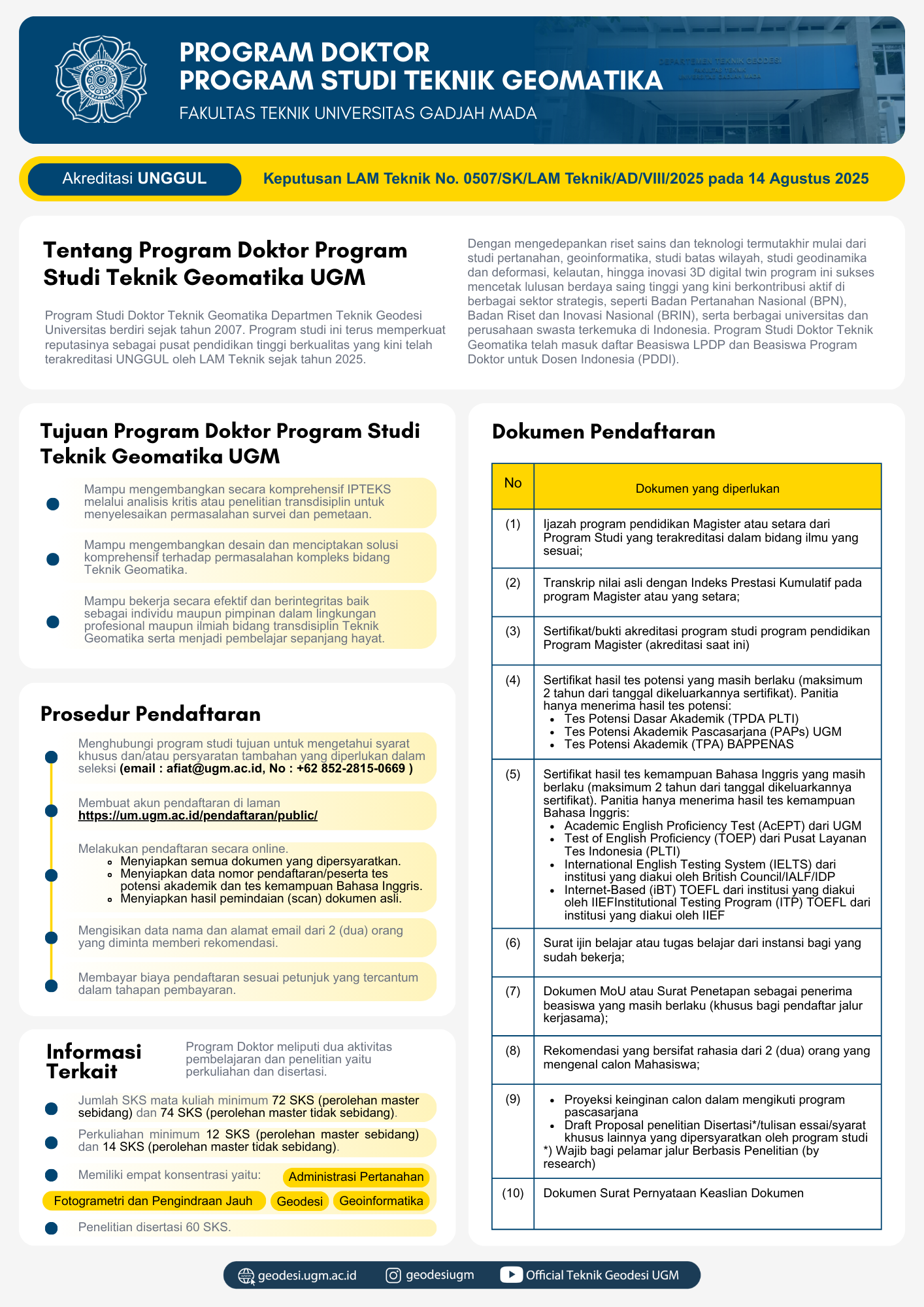
The Doctoral Program in Geomatics Engineering at the Department of Geodesy Engineering was established in 2007. This study program continues to strengthen its reputation as a center of quality higher education, which has now been accredited as EXCELLENT by LAM Teknik since 2025. By prioritizing the latest science and technology research, ranging from land studies, geoinformatics, boundary studies, geodynamics and deformation studies, marine studies, to 3D digital twin innovations, this program has successfully produced highly competitive graduates who are now actively contributing to various strategic sectors, such as the National Land Agency (BPN), the National Research and Innovation Agency (BRIN), as well as various leading universities and private companies in Indonesia. The Doctoral Program in Geomatics Engineering has been included in the LPDP Scholarship and the Doctoral Program Scholarship for Indonesian Lecturers (PDDI). The Doctoral Program in Geomatics Engineering at the Department of Geodesy Engineering was established in 2007. This program continues to strengthen its reputation as a center of quality higher education, which has now been accredited as EXCELLENT by LAM Teknik since 2025.
Vision and Mission of Geomatics Engineering Doctoral Program
The scientific vision of PDPSTGM is “The vision of the Geomatics Engineering Doctoral Study Program FT UGM is to become an effective Doctoral Program and have an international reputation in the field of geomatics engineering, which produces Geomatics Engineering Doctors who master science and technology and have dignity in accordance with the values of Pancasila and serve for the progress of the nation and humanity.”
Scientific mission of PDPSTGM
- In order to achieve the vision of the Study Program, the scientific mission of the Geomatics Engineering Doctoral Study Program of the Department of Geodesy Engineering, Faculty of Engineering, Universitas Gadjah Mada is formulated as follows:
- Organizing doctoral education that is oriented towards achieving program goals with the support of Information Technology in a mix.
Implement innovative and quality research based on the state of the art (SOTA) of the latest scientific findings in the development of science and technology in the field of geomatics engineering for solving engineering and humanitarian problems and initiating novelty in the field of geomatics engineering.
Take an active role in realizing alternative solutions for national and international communities by applying the results of education and research to improve welfare to geospatial information-based communities. - Develop study program management and establish mutually beneficial cooperation with domestic and foreign institutions through Tri Dharma Perguruan Tinggi activities through education and research activities in the field of Geomatics Engineering.


Graduate Profile
Based on the results of the tracer study analysis and the needs of the stakeholders, the Geomatics Engineering Doctoral Program has the following graduate profile formulation:
- Regulators, namely policy makers in government and community sectors related to the field of Geomatics Engineering. For example: Middle & Primary Leaders, Inspectorate.
- Lecturer / Researcher, namely Professionals in the field of Education and research for the scientific development of Geomatics Engineering.
- CTO Surveying and Mapping, professionals who act as leaders of technology development in business entities and businesses related to Geomatics Engineering. For example, Chief of Technology Officer, Chief of Information Officer, Chief of Geospatial Information Officer.
Program Educational Objective (PEO)
The Educational Objective (PEO) of the Study Program is that after working in the community/industry for 3 to 4 years, PDPSTGM graduates will be able to:
- Comprehensively develop science and technology through critical analysis or transdisciplinary research to solve surveying and mapping problems.
- Develop designs and create comprehensive solutions to complex problems in the field of Geomatics Engineering.
- Work effectively and with integrity both as individuals and leaders in professional and scientific environments in the transdisciplinary field of Geomatics Engineering, and become lifelong learners.
Student Outcome (SO)
Based on the Educational Objectives of the Study Program/Program Educational Objective (PEO), the formulation of CPL PDPSTGM is:
- Demonstrate Pancasila attitudes and awareness of the interests of the nation and state.
- Demonstrate honesty, responsibility, self-confidence, emotional maturity, ethics, and professional awareness.
- Be able to develop fundamental geomatics engineering theories for scientific and practical applications.
- Able to comprehensively apply the field of geomatics engineering with a multi-disciplinary approach through research activities by applying the latest geomatics methods and technologies appropriately in accordance with academic principles
- Able to solve scientific and technological problems by utilizing the availability of modern technology, facilities, and infrastructure in the field of geomatics in scientific and professional activities
- Able to think critically, rationally, and objectively based on scientific principles and oriented towards lifelong learning
- Able to communicate and publish thoughts and research results effectively to the scientific community and the general public
- Able to work in multidisciplinary teams through national and international research networks and have academic responsibility and professional ethics
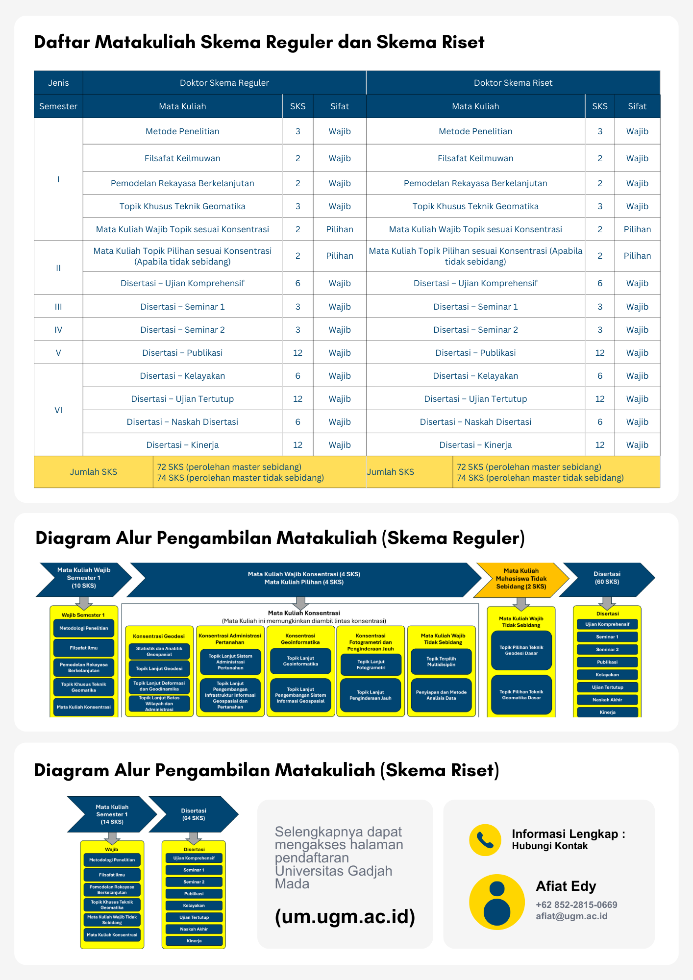
Leaflet Registrasion of Doctor Geomatic Engineering Program