

Department of Geodetic Engineering, Faculty of Engineering, Universitas Gadjah Mada is one of the eight departments within the Faculty of Engineering UGM. At the beginning of its establishment, in August 1959, DTGD was still a joint study program with the Geological Engineering study program called Geodesy and Geology Engineering Section. In 1962, based on Law No. 22 of 1961, the Geodesy and Geology Engineering Section was split into two sections, namely the Geodesy Engineering Section and the Geology Engineering Section, each of which stood alone.
In 1962/1963 the Geodesy Section did not accept students. The Geodesy Section of the Faculty of Engineering, Universitas Gadjah Mada was temporarily “closed”. With the help of UCLA, in 1963 three staff members of the Geodesy Section, namely Prijono, B.Sc., Budihardjo, B.Sc., and Djoko Walijatun, B.Sc., were sent for further study at OHIO State University (OSU). The three of them, along with Rachmad PH., B.Sc., then became permanent lecturers in the Geodesy Section. With the return of the three people from OHIO in 1966, the Geodesy Section was reopened in 1968, with the Head of Section Djoko Walidjatun, M.Sc. and Secretary of Section Budiharjo, M.Sc. Students were able to continue their doctoral studies. Due to the suspension of lectures from 1963-1968, the Geodesy Section of the Faculty of Engineering, Gadjah Mada University, which opened in 1959, was only able to graduate its first graduate in 1969, Ir. Hasyimi Masyidin (aim.) who had served as Secretary of the Geodesy Section for three consecutive periods (1970-1976). After a long period of not sending lecturers abroad for further studies, in 1972 Ir. Soeprapto with MOMBUSHO (Japan) funding got the opportunity to study at Kyoto University as a research student. The second chapter of the Geodesy Section, which opened in 1968, did not seem to be able to overcome the various obstacles that existed. The shortage of lecturers and learning facilities remains a major obstacle.
In 1978, students from the classes of 1968 to 1973 began to accumulate in their final year. There were only six permanent lecturers, with the course load already exceeding reasonable limits. The accumulation of students is not only due to the problem of final assignments but also because some subjects have no lecturers. Realizing this, the Chairperson and the section secretary at that time, Ir. Priyono and Ir. Soeprapto, tried to seek help from various parties. Help soon came, the Chairman of the Geodesy Department of FTSPITB, Ir. Klass J. Vilanueva, Dr. Ing. Syamsir Mira and Drs. Wirahastirto from the Pusdata of the Ministry of Public Works, Lt. Col. Ir. Soewito from JANHIDROS and Ir. Soebagio Taipur, Ir. Sidharta Sumarno from LIPI. Especially for thesis guidance, the Geodesy Section of the Faculty of Engineering, Gadjah Mada University cannot forget the services of Dr. Ir. Soekotjo Tjokrosoewarno who has provided various facilities and intensive guidance. In addition, assistance was also obtained from several staff of JANHIDROS TNI-AL (now DISHIDROS TNI-AL), Bakosurtanal, several surveying and mapping companies in Jakarta, so that many students were helped in completing practical work and final assignments.
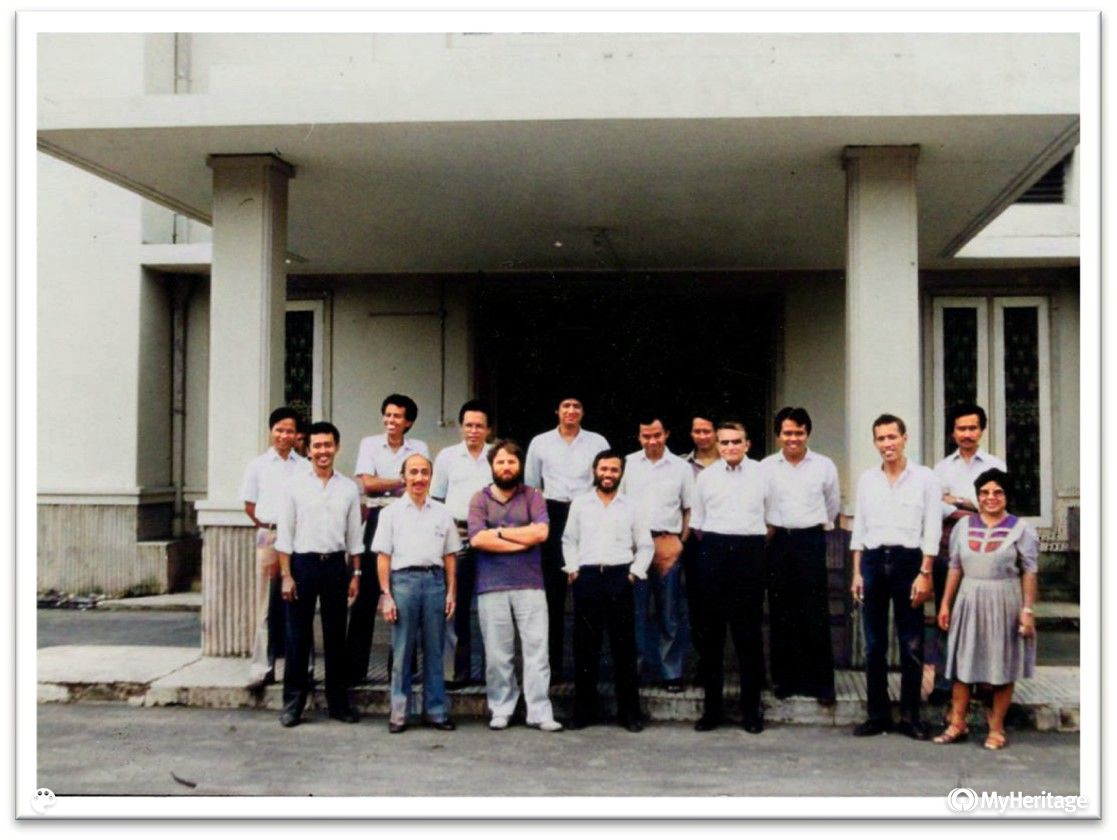
Efforts were made to improve the curriculum and the quality of the teaching staff. In 1984, with the help of World Bank Project IX through the Directorate of Higher Education, under the coordination of Prof. Dr. Ivan Mueller (Ohio State University), Geodesy experts from various countries came to the Department of Geodesy Engineering, Faculty of Engineering, Universitas Gadjah Mada. These experts are: Prof. Dr. Van Gelder (Netherlands), Prof. Dr. Darmanis (Greece), Prof. D. Cubic (UK), Prof. Dr. Arur (India), Prof. Dr. Jiwalay (Thailand), Prof. Dr. Badekas (Germany), Prof. Dr. Zenk (Germany), and Prof. Dr. Yehuda Bock (USA).
Based on the Decree of the Minister of Education and Culture No.0214/u/1979, in 1980 the Geodesy Section officially changed to the Geodesy Engineering Department by implementing a new curriculum using the Semester Credit System (SKS). Thus, since 1980, the Geodetic Engineering Section changed its name to the Geodetic Engineering Department. The Geodetic Engineering Study Program itself had changed its name to Geodesy-Geomatics Engineering Study Program in the 2001 Curriculum period before returning to using the name Geodetic Engineering Study Program. In 2014, the use of this term then changed to ‘department’, so that the Geodetic Engineering Department changed to the Geodetic Engineering Department until now.

Since its inception until 1979, the education system at the Faculty of Engineering UGM (including the Geodetic Engineering Section) used a package system known in several levels of study, namely the Propaedeuse level, Candidate level, Doctoral I level (Bachelor/B.Sc.), and Doctoral II level (Engineer). In 1980, based on the Decree of the Minister of Education and Culture No. 0214/U/1979, the Geodetic Engineering Section was transformed into the Geodetic Engineering Department by implementing a new curriculum in 1980 which for the first time applied the Semester Credit System.
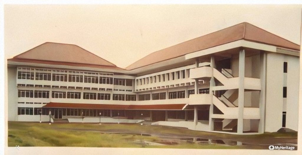
Starting in the 1993/1994 academic year, the Department of Geodetic Engineering occupies a new 3-story campus covering an area of 4,237 m2 in the UGM Faculty of Engineering Complex, Jl. Grafika No. 2, Yogyakarta. While in an effort to keep up with the development of science and technology and the demands of market needs, the Department of Geodetic Engineering FT-UGM has made several curriculum improvements. The 1980 curriculum which has been running for almost 8 years, in 1988 underwent improvements resulting in the 1988 Curriculum. Furthermore, in 1995 an evaluation of the 1988 Curriculum was carried out again to be refined in accordance with the development of science and technology and the enactment of the National Curriculum, resulting in the 1996 Curriculum.
In 2000, an evaluation of the 1996 curriculum was carried out which resulted in the 2001 Curriculum, where the changes were very significant which reduced the number of credits as a graduation requirement from 150 credits to 144 credits only, as well as the study time which was originally arranged in 9 semester years accelerated to only 8 semesters. The curriculum evaluation carried out at that time followed the guidelines: ABET 2000 criteria, which refers to the Indonesian Geomatics Council Competency Standards. In the same year, the name of the Geodetic Engineering Study Program was changed to the name of the Geodesy-Geomatics Engineering Study Program due to a paradigm shift from Geodetic Engineering to Geomatics Engineering, so that Geodetic Engineering graduates not only have the ability to make maps, but also have the ability to process and present earth information that is integrated for use in various fields.
As a commitment to developing the quality of education, in 2006 an evaluation of the 2001 curriculum was carried out which resulted in a new 2006 competency-based curriculum. The 2006 curriculum was prepared based on the Graduate Competencies of the Geodesy and Geomatics Engineering Undergraduate Program which consists of two main competencies (Positioning and mapping; Geo-Information) and two supporting competencies (Engineering Survey; Land management).
In order to revitalize the vision and mission of the Department of Geodetic Engineering FT-UGM, to increase the role and influence of Geodetic Engineering graduates in the national arena and the desire for increased recognition by the international community, in 2010 a review and evaluation of the 2006 curriculum was carried out, which subsequently resulted in the new Curriculum 2011. This was also motivated by academic, community, industry, and graduate user conditions at the local and global levels. With the enactment of the Geospatial Information Law (Law No.4 / 2011) and the implementation of the free market including for surveying and mapping services and technology through AFTA and CAFTA, it has certainly had a direct impact on the Geodetic Engineering profession.
In addition to the above development efforts, the Department of Geodetic Engineering, Faculty of Engineering UGM has also developed and organized several study programs in addition to the regular S-1, namely:
- Diploma I (D-1) Cadastral Surveying and Mapping Program (opened since 1998), which is only opened for cooperation programs. This program no longer accepts new students.
- Diploma III (D-3) Geomatics Engineering Program (opened since 2000), which starting in 2008 became part of the Vocational School of Universitas Gadjah Mada.
- S-1 Self-Supporting Program (Extension Program) Geodesy-Geomatics Engineering (opened since 2000), according to UGM regulations this program no longer accepts new students since the 2009/2010 academic year.
- S-2 Geomatics Engineering Study Program (opened since 2001), until now it is still active and accepts Postgraduate Program Students.
- The S-3 Geomatics Engineering Study Program (opened in 2001), is still active and accepts Postgraduate Program Students.
Since the beginning, the Department of Geodesy Engineering has always tried to improve the quality of education by participating in various national and international accreditations. The first international accreditation at the ASEAN level was obtained from AUN-QA in 2015, followed by ABET international accreditation in 2017 and IABEE accreditation in 2020.

The history of the Department of Geodetic Engineering, along with other departments within the Faculty of Engineering UGM, can be read in more detail in the following book.