Department of Geodetic Engineering – Faculty of Engineering UGM


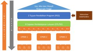
Program Educational Objective (PEO)
The Program Educational Objective (PEO) is that after working in the community/industry for 3 to 4 years, PMTGM graduates are able to:
- Develop skills in geospatial information science and technology based on high scientific demands and comprehensive theoretical knowledge.
- Design, produce, manage, and utilize geospatial information effectively and efficiently using the latest technology for various multi-, inter, and transdisciplinary interests in supporting the achievement of sustainable development goals.
Student Outcome (SO)
Based on the Study Program Educational Objective (PEO), the PEO formulation of the Geomatics Engineering Master Study Program is:
- Able to understand and apply the principles of science and mathematics and the latest engineering in the fields of Geodesy and Geomatics.
- Able to identify, formulate, and solve complex interaction problems between earth sub-systems.
- Able to design engineering systems and processes quantitatively and qualitatively within limits using interdisciplinary and/or multidisciplinary approach methods and techniques.
- Able to communicate effectively in written, oral, and visual communication both within the scope of scientific and general fields.
- Able to demonstrate piety and ethical and professional responsibility.
Able to adapt and reflect, and manage a team with leadership spirit, collaboratively and inclusively. - Able to carry out research and build innovative solutions to engineering, environmental and social problems in a broad scope.
- Able to acquire and apply new knowledge, methods and technology based on information technology critically in continuous professional development.
The following is the relationship between PEO and CPMK and the sub CPMK mentioned in the sub paragraph.