• Tracer Study
  • Civitas Academic Portal
  • SSO Login
  • 🇲🇨 ID
Universitas Gadjah Mada Department of Geodetic Engineering
Universitas Gadjah Mada
  • Profiles
    • What is Geodetic Engineering?
    • History
    • Our Vision
    • Organization
    • Academic Staffs
    • Education Personnel
  • Academics
    • Undergraduated Study Program
    • Master of Geomatics Study Program
    • Doctor of Geomatics Study Program
    • International Undergraduate Program of Geodetic Engineering
  • Student
    • Admission
    • Student Organization
    • Student Activities
    • Living in Jogja
  • Research and Publication
    • Laboratories
    • Research-Community Service
    • Jgise’s Journal
    • CGIS Conference
    • Geo-Land-SEA 2023
  • Facilities
    • Academic Service
    • UGM Integrated Libraries
    • IT Facilities
    • Services
    • Map
  • Home
  • 2017
Arsip:

2017

Webinar Series: Situation of Gunung Agung Activities

NewsResearches Tuesday, 21 November 2017

Gunung Agung is one of the most active volcanoes in Indonesia located in Karangasem regency, Bali. Mount Agung had an increased activity and on September 18, 2017 the Center for Volcanology and Geological Hazard Mitigation (PVMBG) officially raised the status of the alert into alert, as well as on 22 September 2017 rose again to alert. Residents and pets have been evacuated to spread to several evacuations. However on October 29, 2017 PVMBG officially downgraded its status from alert to alert.

Refugees living in evacuation with makeshift facilities, automatically will appear some diseases that attack the refugees. The government, especially the Dinas Kesehatan, also contributed to the handling of these issues, ranging from the health of the IDPs who must be maintained, the trauma healing after the disaster, and many refugees belonging to the vulnerable categories of elderly, pregnant women and toddlers.

As the status of Mount Agung rose, a team from UGM Geodesy Engineering in cooperation with UGM Disaster Response Unit (DERU) and Regional Disaster Management Agency (BPBD) successfully mapping the area around the slopes of Mount Agung using the Buffalo FX-79 drill facility. Visualization gained is very helpful to see the current state of Mount Agung.

Webinar series of November period is the theme of handling situation of Gunung Agung. Discussion and sharing experiences about programs and actions that have been undertaken by the local Dinas Kesehatan in handling the disaster. Besides sharing the experience of the Geodesy Engineering team about the process and finally managed to get the visualization of Mount Agung.

Link for webinar registration: http://www.bencana-kesehatan.net/index.php/65-agenda/2852-webinar-series-situasi-penanganan-aktivitas-gunung-agung

Webinar Series : Situasi Penanganan Aktivitas Gunung Agung

BeritaPenelitian Tuesday, 21 November 2017

Gunung Agung merupakan salah satu gunung api yang masih aktif di Indonesia berlokasi di Kabupaten Karangasem, Bali. Gunung Agung sempat terjadi kenaikan aktivitas dan pada 18 September 2017 Pusat Vulkanologi dan Mitigasi Bencana Geologi (PVMBG) secara resmi menaikkan status dari waspada menjadi siaga, serta pada22 September 2017 naik kembali menjadi awas. Penduduk dan hewan peliharaan pun sudah dilakukan evakuasi yang tersebar ke beberapa pengungsian. Namun pada 29 Oktober 2017 secara resmi PVMBG menurunkan statusnya dari awas menjadi siaga.

Pengungsi yang tinggal di pengungsian dengan fasilitas seadanya, secara otomatis akan muncul beberapa penyakit yang menyerang pengungsi. Pemerintah terutama Dinas Kesehatan pun turut andil dalam penanganan permasalahan tersebut, mulai dari kesehatan pengungsi yang harus terjaga, trauma healing paska bencana, serta banyak pengungsi yang termasuk kategori rentan yakni usia lanjut, ibu hamil, dan balita.

Pada saat status Gunung Agung naik, tim dari Teknik Geodesi UGM yang bekerjasama dengan Disaster Response Unit (DERU) UGM dan Badan Penanggulangan Bencana Daerah (BPBD) berhasil melakukan pemetaan wilayah di sekitar lereng Gunung Agung dengan menggunakan fasilitas drone Buffalo FX-79. Visualisasi yang didapatkan sangat membantu untuk melihat keadaan terkini dari Gunung Agung.

Webinar series periode November mengangkat tema tentang situasi penanganan Gunung Agung. Diskusi dan berbagi pengalaman mengenai program dan tindakan yang telah dilakukan oleh Dinas Kesehatan setempat dalam penanganan bencana tersebut. Selain itu sharing pengalaman tim Teknik Geodesi mengenai proses dan akhirnya berhasil mendapatkan visualisasi Gunung Agung.


Link untuk pendaftaran webinar: http://www.bencana-kesehatan.net/index.php/65-agenda/2852-webinar-series-situasi-penanganan-aktivitas-gunung-agung
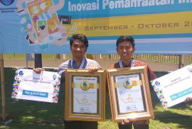
Dua Tim Mahasiswa Teknik Geodesi UGM Menyabet Juara 2 dan 3 Lomba GeoInnovation Bootcamp Badan Informasi Geospasial

BeritaKegiatan Mahasiswa Tuesday, 24 October 2017

Dua orang tim yang diketuai oleh dua mahasiswa Teknik Geodesi UGM atas nama David M. Yusuf dan Akhlis Herin berhasil menyabet masing-masing juara 2 dan 3 lomba Geoinnovation Bootcamp yang diselenggarakan oleh Badan Informasi Geospasial (BIG) pada awal Bulan Oktober yang lalu. Tim yang diawaki oleh David dan Akhlis masing-masing berkompetisi dengan puluhan tim lain dari seluruh Indonesia untuk menyajikan ide yang paling inovatif dalam bidang Geospasial.

Tim David dan Akhlis sukses melewati seleksi yang melibatkan puluhan tim lain pada babak penyisihan yang diselenggarakan di Saung Dolken, Bogor pada tanggal 14-16 Oktober 2017. Tim keduanya merupakan bagian dari tujuh tim lain yang lolos seleksi awal GeoInnovation Bootcamp pada babak penyisihan sebagaimana diberitakan sebelumnya. Pada babak selanjutnya, tiga tim dari Teknik Geodesi UGM berhasil masuk dalam sepuluh besar, sehingga akhirnya diputuskan tim David dan Akhlis berhasil lolos sebagai juara kedua dan ketiga.


General Lecture and Software Licenses Grant from ERDAS Software

News Friday, 20 October 2017

On September 26, 2017, a public lecture and ERDAS software grant from Leica Geosystems Indonesia to the UGM Geodetic Engineering Department was held. A total of 500 software licenses consisting of three leading products of ERDAS, Geomedia Desktop 2016, ERDAS Foundation 2016 and ERDAS IMAGINE 2016 are distributed free of charge to UGM Geodetic Engineering Department students interested in using GIS, Photogrammetry and Remote Sensing software.

Along with the symbolic software license submission, a public lecture by Bpk. Badruszaman and Bpk. Arvy Fachrully as representative of Leica Geosystems Indonesia. In his general lecture, Mr. Badruszaman explained about the progress of survey and mapping technology in Indonesia, especially on airborne mapping for photogrammetry, LiDAR and hydrography. Students who attend seem interested in following the explanation delivered, as evidenced by the many questions asked to the presenters about the presentation submitted. The public lecture and licensing ceremony was then ended by doorprice-sharing from Leica Geosystems to some of the lucky students.

Geodetic Engineering Student Won Gold in PIMNAS 2017

NewsStudents' Activities Friday, 20 October 2017

At the 30th National Student Scientific Competition (PIMNAS) competition organized by Kemenristekdikti at Universitas Muslim Indonesia Makassar on 23rd to 28th of August 2017, one of the team from Universitas Gadjah Mada won the 1st Winner of PKM Entrepreneurship. The team consists of Ali Surojaya (Engineering Geodesi 2016) as chairman, and comprises Muhammad Fahriza (Engineering Physics 2016), Marisha Salsabila (Computer Science 2016), Muhammad Nizar Rahman (Computer Science 2016), and Maulidini Fatimah Azahra (Remote Sensing and GIS 2016). With the guidance of Dr.Eng Herianto, S.T, M.Eng.

Raising the theme of educational media to raise awareness of technological innovation for children in Indonesia with Title Eldu Kit. The team was selected to be one of the 3,918 proposals funded from 77,678 proposed PKM proposal titles. The implementation of the Student Creativity Program (PKM) activity is quite long, after passing funded, each team must conduct Monitoring and Evaluation activities. Only then was elected 420 PKM title that pass to compete in this 30th PIMNAS event.

In this PIMNAS there are two main activities namely Poster Scientific and Presentation Exhibition, with each will be contested champion in each category. Of the total 23 medals achieved by UGM, Team Eldu Kit successfully contributed 1 Gold Medal in Presentation category. Gadjah Mada University won the title with details of 3 Gold Medals, 2 Silver Medals, and 2 Bronze Medals in the Presentation category. And 5 Gold Medals, 5 Silver Medals, and 6 Bronze Medals in the Poster category. In addition UGM also won 10 Favorite Awards.

Seven Teams of Geodetic Engineering Students Pass The Selection to GeoInnovation Bootcamp

Uncategorized Friday, 20 October 2017

A total of seven teams each consisting of a mixture of UGM Geodetic Engineering students and other departments at UGM pass the selection stage to follow the GeoInnovation Bootcamp held by the Geospatial Information Agency (BIG) at Saung Dolken, October 14 to 16, 2017. Here are 25 best innovations who were invited to follow the Geoinnovation Bootcamp agenda in Bogor:


Free ERDAS Software Licenses for Students of Geodetic Engineering Students

News Friday, 20 October 2017

Leica Geosystems Indonesia in cooperation with UGM Geodesy Engineering Department provides 500 free ERDAS software licenses for use by students. Here are the free shared software:

1. GeoMedia Desktop 2016

2. ERDAS Foundation 2016

3. ERDAS IMAGINE 2016 (64 bit or 32 bit)

All three software can be used by students who are interested to explore the field of GIS, photogrammetry and remote sensing using ERDAS software. Technical installation and licensing implementation can contact Dany Laksono at Lt.1 Building Geodesy Engineering UGM.

Lisensi Software ERDAS Gratis untuk Mahasiswa Teknik Geodesi

BeritaLowongan, Beasiswa dan Lomba Wednesday, 18 October 2017

Leica Geosystems Indonesia bekerjasama dengan Departemen Teknik Geodesi UGM memberikan 500 lisensi software ERDAS gratis untuk digunakan oleh mahasiswa. Berikut adalah perangkat lunak yang dibagikan gratis:

1.       GeoMedia Desktop 2016

2.       ERDAS Foundation 2016

3.       ERDAS IMAGINE 2016 (64 bit or 32 bit)

Ketiga perangkat lunak tersebut dapat digunakan oleh mahasiswa yang berminat untuk mendalami bidang GIS, fotogrametri dan remote sensing dengan menggunakan perangkat lunak ERDAS. Teknis instalasi dan penerapan lisensi dapat menghubungi Dany Laksono di Lt.1 Gedung Teknik Geodesi UGM.

Tujuh Tim Mahasiswa Teknik Geodesi Lolos ke GeoInnovation Bootcamp 2017

Uncategorized Tuesday, 17 October 2017

Sejumlah tujuh tim yang masing-masing terdiri dari gabungan mahasiswa Teknik Geodesi UGM dan departemen lain di UGM lolos tahap seleksi untuk mengikuti GeoInnovation Bootcamp yang diadakan oleh Badan Informasi Geospasial (BIG) di Saung Dolken, 14 – 16 Oktober 2017. Berikut adalah 25 innovasi terbaik yang diundang untuk mengikuti agenda Geoinnovation Bootcamp di Bogor:

Kuliah Umum dan Penyerahan Hibah Software ERDAS

Berita Wednesday, 27 September 2017

Pada tanggal 26 September 2017 dilaksanakan kuliah umum sekaligus hibah perangkat lunak ERDAS dari Leica Geosystems Indonesia kepada Departemen Teknik Geodesi UGM. Sejumlah 500 lisensi perangkat lunak yang terdiri dari tiga produk unggulan ERDAS yaitu Geomedia Desktop 2016, ERDAS Foundation 2016 serta ERDAS IMAGINE 2016 dibagikan secara gratis kepada mahasiswa Departemen Teknik Geodesi UGM yang berminat untuk menggunakan perangkat lunak berbasis GIS, fotogrametri dan Remote sensing ini.

Bersamaan dengan penyerahan lisensi software secara simbolis, dilaksanakan pula kuliah umum oleh Bpk. Badruszaman dan Bpk. Arvy Fachrully selaku perwakilan Leica Geosystems Indonesia. Dalam kuliah umumnya, Bapak Badruszaman menjelaskan mengenai kemajuan teknologi survey dan pemetaan di Indonesia, khususnya mengenai pemetaan berbasis udara (Airborne Mapping), baik untuk keperluan fotogrametri, LiDAR maupun hidrografi. Mahasiswa yang hadir tampak berminat mengikuti penjelasan yang disampaikan, terbukti dari banyaknya pertanyaan yang diajukan kepada pemateri mengenai presentasi yang disampaikan. Acara kuliah umum dan penyerahan lisensi ini kemudian diakhiri dengan pembagian doorprise dari Leica Geosystems kepada beberapa mahasiswa yang beruntung.

123

Agenda

May 2025
M T W T F S S
 1234
567891011
12131415161718
19202122232425
262728293031  
« Sep    

Recent Posts

  • A Talk on Digital Twin for Mining Operations from Prof. Trias Aditya on the occasion of ASABA Geo Tech Summit 2024
  • Guest Lecture by Trias Aditya at TUM, Germany
  • Selected Participants for Short Course, “UAV Photogrammetry for 3D Model Reconstruction and Inspection”
  • Empat Program Studi UGM Dapat Akreditasi Internasional ABET
  • Menangi Kompetisi dengan Aplikasi Pariwisata, Mahasiswi UGM dikirim ke California
Universitas Gadjah Mada

Department of Geodetic Engineering

Faculty of Geodetic Engineering Universitas Gadjah Mada
Jl. Grafika no.2 Bulaksumur, Yogyakarta, 55281
  (+62274) 520226
  geodesi@ugm.ac.id

Direktori

  • Universitas Gadjah Mada
  • Fakultas Teknik UGM
  • Jurnal JGISE

Tautan

  • Jurnal Geodesi
  • Katdesi
  • KMTG
  • Geodeta UGM

Sosial Media

  • Instagram
  • Twiter
  • Facebook
  • Email

© Universitas Gadjah Mada

KEBIJAKAN PRIVASI/PRIVACY POLICY